School nearby Maxcom Training Institute
Maldives
School nearby Maxcom Training Institute
Maxcom Training Institute
20 Lonuziyaarai Magu Rd, Malé 20110, Lonuziyaarai Magu Road, 20110, Malé, MV Maldives
contacts phone
:
+960 300-5585
website:
www.mts.mv
Latitude:
4.1726358
, Longitude:
73.5106211
larger map & directions
read more
nearest School
101 m
Police Academy
Galolhu
School
read more
112 m
Jamaluddin School
167 Rah Dhebai Magu Road, Malé
School
read more
168 m
Galolhu Madhrasa
Galolhu
School
read more
174 m
Salahuddin Building
371 Ameenee Magu, Malé
School
read more
190 m
Imaduddin School
Ameenee Magu, Malé
School
read more
209 m
Billabong High EPS International School
Ameenee Magu, Malé
School
read more
264 m
IHQ
Chaandhanee Magu, Malé
School
read more
289 m
Dhondhooni Little Learners Preschool, Jalaluddin Campus
Iskandhar Magu, Malé
School
read more
366 m
Dhi Print And Publisher
Malé
School
read more
412 m
Lead Tution center
Machangolhi
School
read more
425 m
Iskandhar School
Chaandhanee Magu, Malé
School
read more
450 m
Centre for Higher Secondary Education
Lily Magu, Malé
School
read more
456 m
MIT Electrical Work shop
Machangolhi
School
read more
463 m
Kalaafaanu School
20065, Ameenee Magu, Malé
School
read more
487 m
KangarooKids Preschool
Lonuziyaarai Magu, Male'
School
read more
494 m
Arabiyya School
Malé,, Malé
School
read more
509 m
Forloop Coding Academy
Galolhu
School
read more
511 m
Excel International School
Raimuige, 2nd Floor, Sayyid Kilegefaanu Magu
School
read more
529 m
PL Kids Preschool
G. Moonimaage, Dharumavantha magu, Malé
School
read more
599 m
LLC Maldives
M. Varutha, Asaree Hingun, Malé
School
read more
622 m
CITM
360 Janavaree Magu
School
read more
659 m
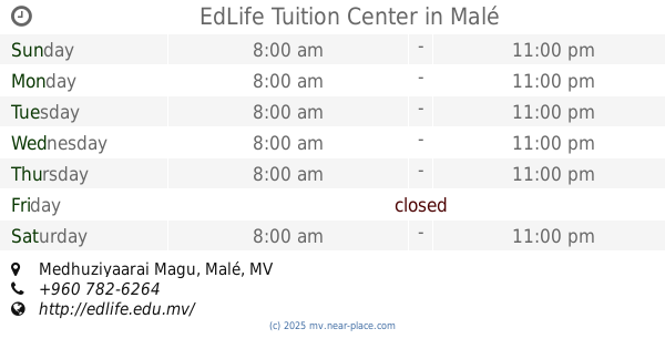
EdLife Tuition Center
Medhuziyaarai Magu, Malé
School
read more
772 m
Kinder Preschool
Male, Iramaa Magu, Malé
School
read more
789 m
Jamiyyathul Falah
Malé
School
read more
849 m
PL Kids Preschool
Male, Filigas Magu, Malé
School
read more
📑
all categories
Accounting
Administrative area level 2
Airport
Amusement park
Art gallery
Atm
Bakery
Bank
Bar
Beauty salon
Bicycle store
Book store
Bus station
Cafe
Car repair
Cemetery
City hall
Clothing store
Colloquial area
Convenience store
Country
Courthouse
Dentist
Department store
Doctor
Electronics store
Embassy
Finance
Fire station
Florist
Food
Funeral home
Furniture store
Gas station
General contractor
Grocery or supermarket
Gym
Hair care
Hardware store
Health
Home goods store
Hospital
Insurance agency
Jewelry store
Laundry
Lawyer
Library
Local government office
Locality
Lodging
Meal delivery
Meal takeaway
Mosque
Movie rental
Movie theater
Moving company
Museum
Natural feature
Neighborhood
Night club
Park
Parking
Pet store
Pharmacy
Point of interest
Police
Post office
Premise
Real estate agency
Restaurant
Route
School
Shoe store
Shopping mall
Spa
Stadium
Storage
Store
Supermarket
Transit station
Travel agency
University
sublocality level 1
↑